RIVER GAUGES
Real-time streamflow data is readily available online and through the use of mobile apps:
The USGS and NWS pages display stream status (high, low, flood, etc.) as colored, clickable icons. That can be useful for a quick assessment, but you'll want to click on your gauge of interest.
Gauge Height (a.k.a. Stage) as provided by the USGS, NWS and USACE indicates the measurement of the water surface above a locally established reference point (e.g. the top of a bridge pier footing), NOT the actual stream depth. IFIS Gauges report the water surface elevation above sea level, from which stream depth can be determined.*
Discharge (a.k.a. Flow or Streamflow), in cubic feet per second (cfs) is a calculated value that can be useful when comparing values to other known streams. (You may find that the USGS doesn't publish discharge data in winter, but you'll still see it on the NWS and USACE pages.)
By noting the relevant gauge reading(s) after each trip, users can establish a range of stream levels that suit their personal preferences. Lacking that knowledge or specific guidance from trusted sources (e.g. Paddling Iowa), they might choose to avoid anything above or below normal**, depending on their skill level, that of their paddling partner(s), local conditions, etc.
- US Geological Survey (USGS) National Water Dashboard
- National Weather Service (NWS) River Observations and Forecasts
- U.S. Army Corp of Engineers (USACE) RiverGauges.com
- Iowa Flood Center (Iowa Flood Information System or IFIS)
- RiverApp (One of several available Apple and Android Apps.)
The USGS and NWS pages display stream status (high, low, flood, etc.) as colored, clickable icons. That can be useful for a quick assessment, but you'll want to click on your gauge of interest.
Gauge Height (a.k.a. Stage) as provided by the USGS, NWS and USACE indicates the measurement of the water surface above a locally established reference point (e.g. the top of a bridge pier footing), NOT the actual stream depth. IFIS Gauges report the water surface elevation above sea level, from which stream depth can be determined.*
Discharge (a.k.a. Flow or Streamflow), in cubic feet per second (cfs) is a calculated value that can be useful when comparing values to other known streams. (You may find that the USGS doesn't publish discharge data in winter, but you'll still see it on the NWS and USACE pages.)
By noting the relevant gauge reading(s) after each trip, users can establish a range of stream levels that suit their personal preferences. Lacking that knowledge or specific guidance from trusted sources (e.g. Paddling Iowa), they might choose to avoid anything above or below normal**, depending on their skill level, that of their paddling partner(s), local conditions, etc.
Digging Deeper: There's a wealth of information available within these online resources. For example, on many of the USGS "Legacy" Pages (such as the South Skunk above Ames) you'll see a table comparing the current discharge with historical data for that gauge and day of the year. Here's a table clipped from the South Skunk above Ames Gauge page some years ago.
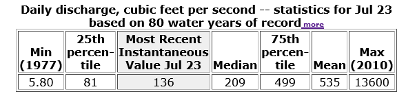
This table indicates that the historical mean for July 23rd was 535 cfs, and that 75% of all daily mean values were under 499 cfs. For the Skunk above Ames, one could consider both numbers to be normal and even safe** levels for most river users.
The numbers you see in the above table will vary with the seasons, so once you've found the table of your gauge of interest, click on "more" to open a table of Mean of Daily Mean Values for the entire year.***
For the South Skunk above Ames the historical data indicates that mean flows are highest during the month of June (typical for Iowa), and one could assume that those numbers are also "normal" for that part of the Skunk.
Most local paddlers would consider the minimum flow above Ames/Ioway Creek to be somewhere near 100 cfs, but those who don't mind stepping out for the riffles may enjoy paddling the pools even at very low flows. Even below 50 cfs!
* The IFIS gauges report the water surface elevation above sea level along with the elevation of the gauge sensor, so you can determine (or select to display) actual stream depth at the gauge site. IFIS Gauges don't include discharge data but are often useful when there are no USGS, NWS or USACE Gauges nearby.
** It's important to remember that there can be hazards on the river even at normal and low flows. Most are easily avoided by skilled boaters, but river reading and boat handing skills become increasingly important as streamflow increases, and rescues and recoveries become increasingly difficult with increased velocity and depth. Know the flow before you go, and if you're unsure, it might be wise to postpone your trip!
*** A Mean of Daily Mean Values table can also be created (and customized) from a drop-down box on the Legacy Page. Select "Available Data For This Site" and then "Time-Series: Daily statistics."